
Geography of Hokkaido
ページ内目次
Geography of Hokkaido
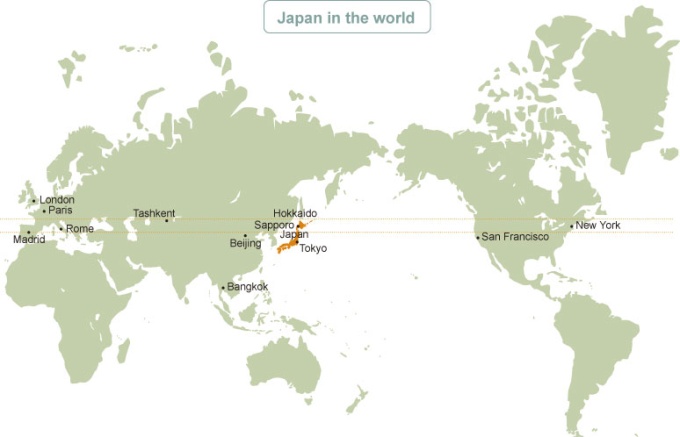
Location
139°20’ – 148°53’ E. Long. 41°21’ – 45°33’ N. Lat.
Despite being at the northern tip of Japan, Hokkaido is located on similar latitudes to major American and European cities.
Despite being at the northern tip of Japan, Hokkaido is located on similar latitudes to major American and European cities.
Area
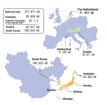
83,424 km2 (including 5,003 km2 of the Northern Territories) Accounting for 22% of the total area of Japan (October 2014), it is the largest prefecture and is equivalent to the size of Austria or twice that of the Netherlands or Switzerland.
Population
5,381,733 (according to the 2015 National Census), which accounts for approximately 4.2% of Japan’s total population.
Of these, 1.95 million are concentrated in Sapporo. Population density is 70 persons/km2 (1/5 of the national average).
Of these, 1.95 million are concentrated in Sapporo. Population density is 70 persons/km2 (1/5 of the national average).
Climate
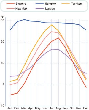
Hokkaido’s annual mean temperature (Sapporo) is around 8.9ºC, which is similar to that of Chicago or Boston in North America.
Hokkaido enjoys four distinct seasons with no rainy season and a cool, refreshing summer with low humidity. In winter, there is considerable snowfall on the Sea of Japan side and there are many days with freezing temperatures even in the daytime.
Hokkaido enjoys four distinct seasons with no rainy season and a cool, refreshing summer with low humidity. In winter, there is considerable snowfall on the Sea of Japan side and there are many days with freezing temperatures even in the daytime.
Topography
Surrounded in all four directions by the Pacific Ocean, the Sea of Japan and the Sea of Okhotsk, Hokkaido is home to a variety of magnificent mountains, extensive wetlands, beautiful lakes, marshes, rivers, forests and more. With expansive farmland, also referred to as the breadbasket of Japan, the prefecture produces a variety of products, consisting mainly of rice, dry-field crops, and dairy and livestock products.
Hokkaido has two volcanic zones, along which many volcanoes and hot springs exist.
Hokkaido has two volcanic zones, along which many volcanoes and hot springs exist.
Administrative division
Hokkaido is one of the 47 prefectures of Japan. It has 179 municipalities in total – 35 cities, 129 towns and 15 villages – the largest number of municipalities in any other prefectures (as of March, 2016).
Japan’s Northern Territories
The territorial issues over four northern islands – Etorofu, Kunashiri, Shikotan and the Habomai Islands – remain unresolved with Russia since 1945. The Hokkaido Bureau, recognizing the economic difficulties of the Nemuro area, which formerly had strong economic links with the territories, places great emphasis on promoting activities that contribute to improving the area’s prospects.
Comparison of areas
Topography of Japan and comparison of areas
Four seasons in Hokkaido
With its rich and spectacular natural environment, Hokkaido is ideal for leisure and recreational activities.
-
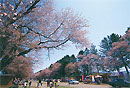
Cherry trees along Nijukken Road
-
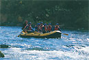
Rafting on the Shiribetsu River
-
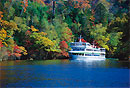
Autumn leaves at Lake Akan
-
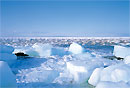
Drift ice on the Sea of Okhotsk
Comparison of mean temperatures
Comparison of mean temperatures of Sapporo and major cities in the world.
Address:Nishi 2-chome,Kita 8-jo Kita-ku, Sapporo-si, Hokkaido 060-8511 Japan
Tel:011-709-2311 Mail:hkd-ky-koho_info0@gxb.mlit.go.jp
Tel:011-709-2311 Mail:hkd-ky-koho_info0@gxb.mlit.go.jp