Satunaigawa Dam web site(Outline of Satunaigawa Dam)
Outline of Satunaigawa Dam
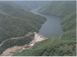
The Tokachigawa River's source is Tokachidake Mountain in the Daisetsuzan Range. This class A river is 156km long and has a catchment area of 9,010km². The Satsunaigawa River is one of the three largest tributaries of the Tokachigawa River. Its source is Satsunaidake Mountain in the Hidaka Range, and it flows into the Tokachigawa River in the central part of the Tokachi plains. It is 82km long and has a catchment area of 725km²
The land slopes steeply in the central part of the Tokachi basin, where tributaries of the Tokachigawa River meet. As result, the area has suffered from flooding many times.
Over the years, demand for city water in Obihiro City and the six other towns and villages located in the basin has increased. As a result, a new water source has become neccessary.
We constructed Satsunaigawa Dam in order to solve these problems, supply the water necessary to develop Tokachi's agriculture, and generate hydroelectric power.
Because the dam is located in Hidaka Mountains Erimo Quasi-National Park, we chose construction methods that would have minimal effect on the environment.