1 Controlling inflow of sediment with riverside forests and retarding
ページ内目次
Proposal for Conservation of the River Environment in Kushiro Mire
Ⅲ Measures to meet the targets
- 1 Controlling inflow of sediment with riverside forests and retarding basin.
- 2 Re-afforestation to increase water retention and prevent sediment production.
- 3 Regeneration of the mire.
- 4 Controlling the mire vegetation.
- 5 Restoring straightened rivers to meandering courses.
- 6 Conserving the water environment.
- 7 Conserving the wildlife habitat.
- 8 Conserving the wetland landscape.
- 9 Citizens' participation in study and management of the mire.
- 10 Common understanding of conservation and wise use of the mire.
- 11 Promoting environmental education.
- 12 Regional cooperation and regional promotion.
1 Controlling inflow of sediment with riverside forests and retarding
To prevent sediment from flowing into the mire, it is necessary to make a series of waterside forests along rivers, and to establish a sediment-regulating area where rivers enter the mire. Construction must aim to achieve water purification and support the functions of a network of biotopes.
[Concept]
・Loads in the catchment basin should be as small as possible.
・Loads in the catchment basin should be understood as divided into coarse-grained sediment, fine-grained sediment and nutrient salts.
・The amount of coarse-grained sediment must be decreased to that when rivers were meandering, at which time sediment inflow to the mire is believed to have been small. The aim is a 40% decrease from present levels.
・It is difficult to set a specific target concerning fine-grained sediment, but based on evaluation of the effects of various measures, proper measures are to be taken.
・As for nutrient salts, the load from the catchment basin must be decreased by 20%, using nitrogen as the indicator.
・Inflow load is considered to correlate with peak of river discharge. The formation of a healthy water cycle is to be encouraged.
[Specific measures]Countermeasures to reduce sediment inflow with waterside afforestation and the creation of buffer zones
By making a series of waterside forests whose width is at least 20 m along both sides of a river, inflow of sediment and nutrient salts into a river will be decreased. Key places are selected to enhance the environmental value, after considering the land use in the vicinity. The rivers involved are listed below. The river extension here is based on The River Law. The measures are to be implemented based on detailed examinations of these rivers.
・Kushiro River (extension: 113.0km)
・Setsuri River (extension: 34.3km)
・Hororo River (extension: 42.5km)
・Kuchoro River (extension: 45.0km)
・Osobetsu River (extension: 26.3km)
・Numaoro River (extension: 31.0km)
The Kuchoro River has been chosen as a model. The measures are to be implemented, with a five-year target for completion, from where the river enters the mire to about 15 km upstream of that, a reach that is considered to have large volumes of sediment inflow as a result of hinterland development and destruction.
Buffer zones, including series of shrubs, are to be created along drainage canals and roads on agricultural land in the catchment basin, where loads are considered large.
-
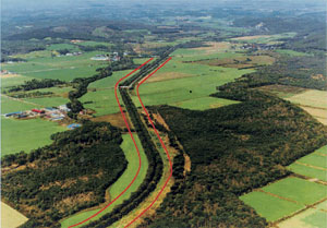
Both sides of the river (a stretch of about 15 km)
Countermeasures to reduce sediment inflow with waterside afforestation and the creation of buffer zones
At the inflow to the mire, on unused land along rivers, at the confluence of drainage canals and elsewhere, sediment-regulating areas are to be constructed to control the amount and quality of sediment and nutrient salts, by storing them temporarily. These areas are designed to be functioning biotopes.
The targeted rivers total six: the Kushiro, Setsuri, Hororo, Kuchoro, Osobetsu and Numaoro. Sediment-regulating areas are to be constructed on unused land and other land along rivers. Details are as follows:
・Floodwaters shall be permitted to flow from the river into the low, flat area where the river enters the mire, thereby enabling the mire to serve as a settling basin.
・A settling basin is to be constructed before the confluence of agricultural drainage canals and the river.
・Sediment-regulating areas are to be constructed in places such as unused land along rivers and where rivers enter the mire.
These measures are to be implemented within five years, based on the evaluations of their effects in the case of the catchment basin of Kuchoro River. In the other catchment basins, these measures are to be implemented by establishing experimental areas for evaluation of the effects.
-
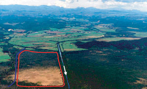
Illustration of the measures (where the rivers enter the mire)
Channel stabilization measures
Protection works and groundsill works are to be carried out in order to prevent bank erosion and riverbed degradation. Details are as follows:
・Nakakuchoro area: Groundsill works and other channel stabilization measures are to be implemented on about 1 km of the rivers length.
・Nakakuchoro area: Groundsill works and other channel stabilization measures are to be implemented on about 1 km of the rivers length.
-
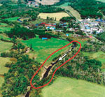
Illustration of the measures(in a place with bank erosion and riverbed degradation)※
-
Photo of improvement (eco-friendly groundsill works in Bavaria, Germany)
※Projected image at the completion of the respective project.