Sediment reduction flowing into the wetland
Sediment reduction flowing into the wetland
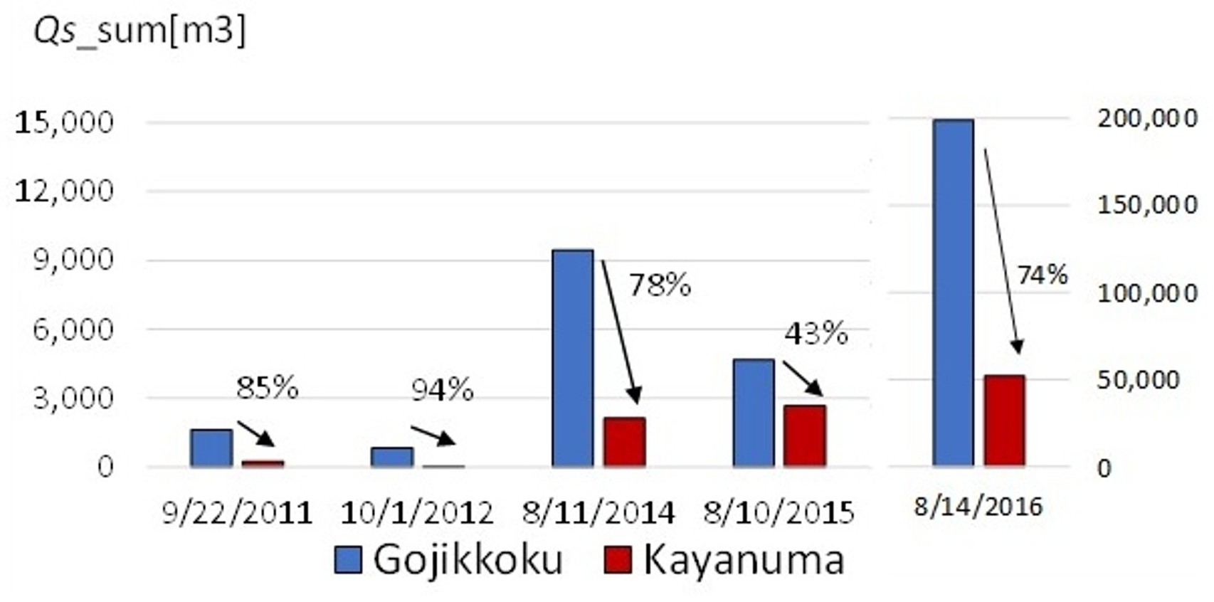
KayanumaChannel re-meandering was implemented in the middle reach of the Kushiro River, in an area known as the Kayanuma district. This site is located approximately 30 km upstream from the river mouth. The project involved reconnecting an abandoned channel to the straightened channel. The primary objective of this reconnection was to increase the overflow of water and suspended sediment. Because the site is located at the edge of the wetland, the project is expected to reduce sediment intrusion into the central wetland carried by floodwaters.In addition, the project aims to restore the former channel to enhance fish habitat, promote the recovery of wetland vegetation in the central wetland, and improve the natural river landscape. The flow was diverted into the former channel in 2010. 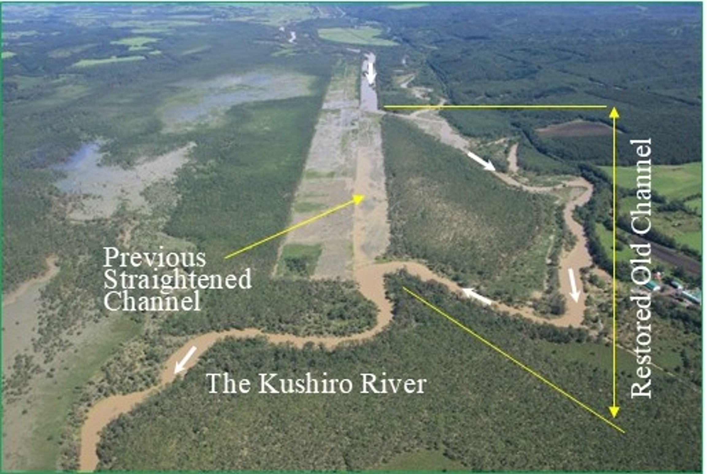 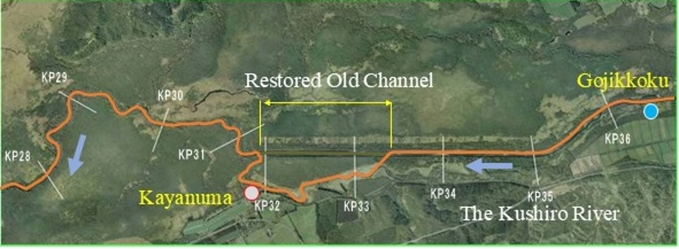 A major flood occurred across Hokkaido in 2016, and this site experienced flooding similar to that in other areas. Monitoring surveys of sediment have been conducted before and after the restoration, including during the 2016 flood. The reduction in sediment load at this site is estimated from the difference in observed suspended load between the upstream station at Gojikkoku and the downstream station at Kayanuma. At the peak of the 2016 flood, the discharge at the upstream Gojikkoku station was approximately 500 m³/s, whereas it decreased to approximately 100 m³/s at the downstream Kayanuma station. This result indicates that about 400 m³/s of discharge overflowed from the channel. Using the relationship between discharge (Q) and suspended load (Qs), the volume of suspended sediment transported in the water is estimated from the discharge. 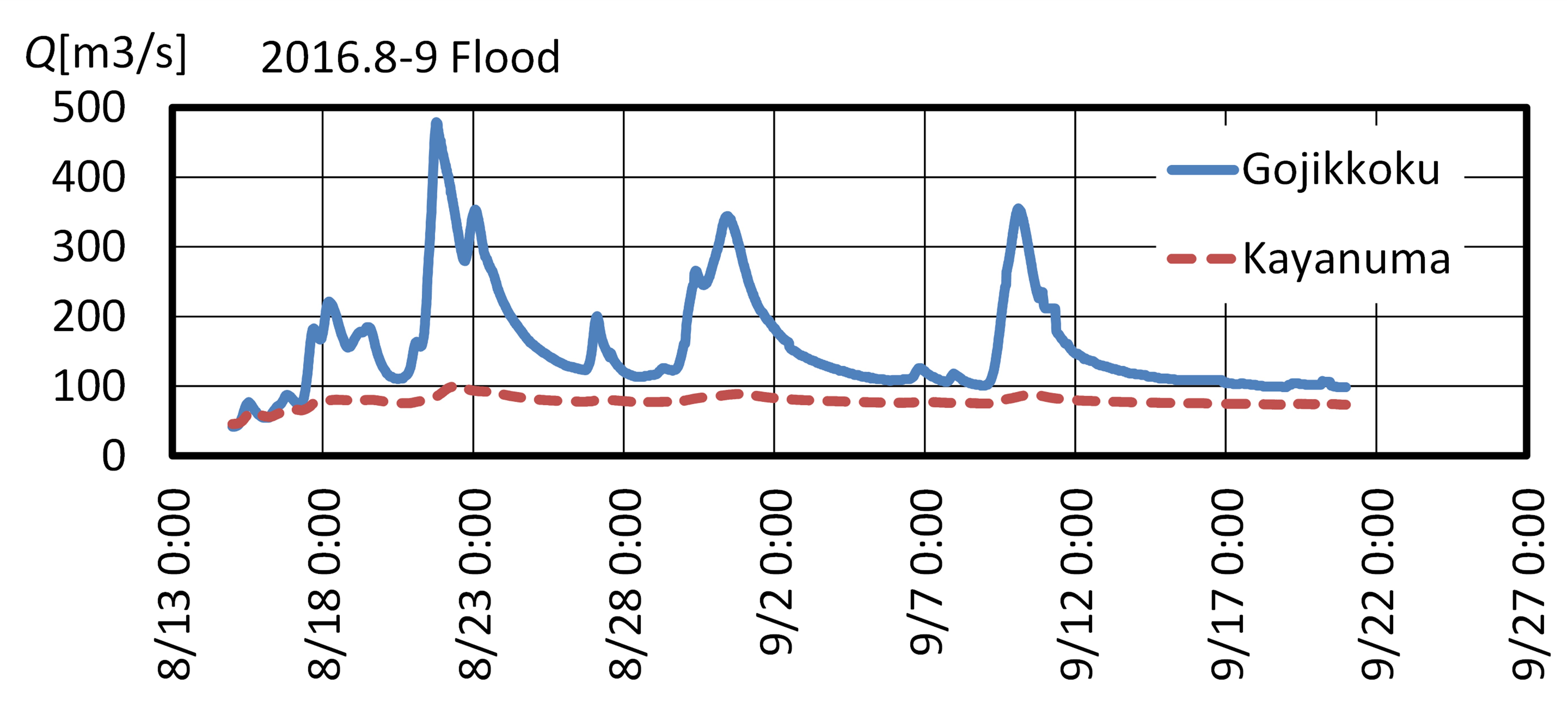 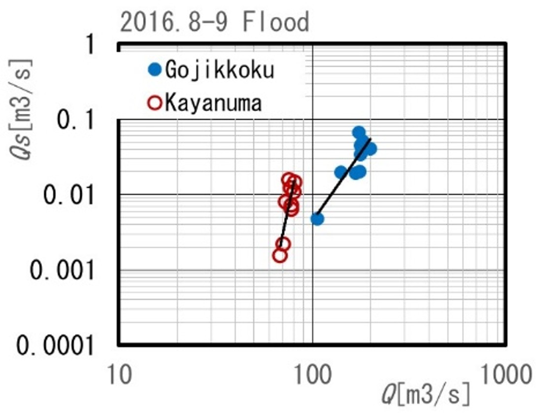
EVALUATIONThe observation results show that the reduction ratio was approximately 50% for floodwater and 40–90% for suspended load. It was also found that the concentration of suspended load increased after passing through this site.Relatively low-concentration surface water overflowed from the channel, while the remaining water with a higher suspended sediment concentration continued flowing downstream. However, the total amount of suspended load transported downstream is assumed to decrease because the discharge volume was significantly reduced. 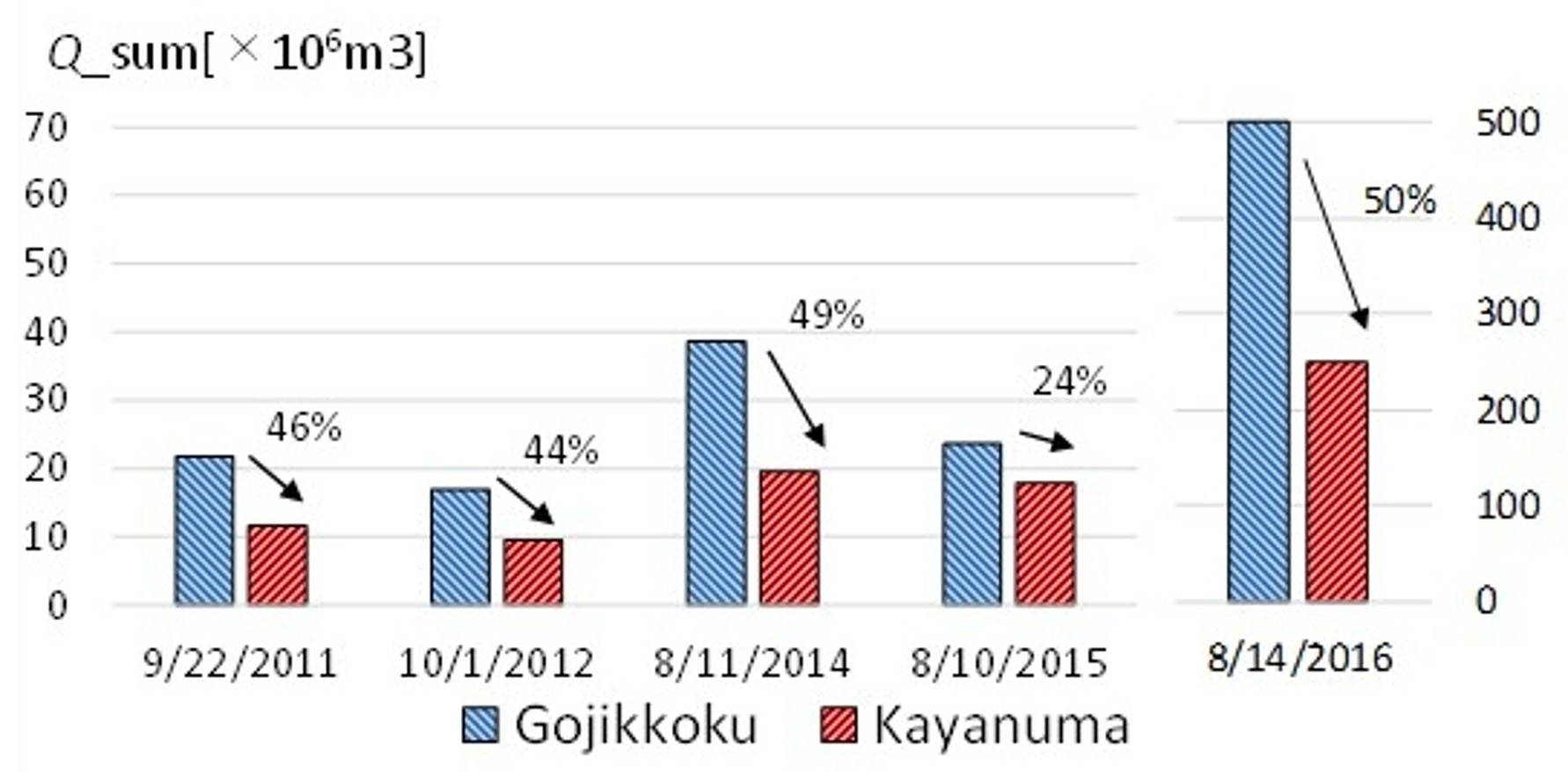
 Numerical simulations were carried out for both the previously straightened channel and the currently restored channel. A comparison of the simulation results shows an increase in sediment accumulation around this channel reach after the channel switching. In addition, the annual sediment reduction was estimated using this simulation model. The results indicate that the annual sediment reduction effect is approximately 40% due to the channel switching. 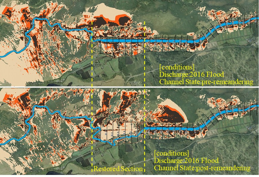 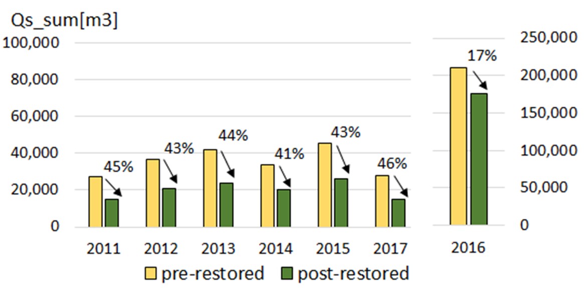 Kuchoro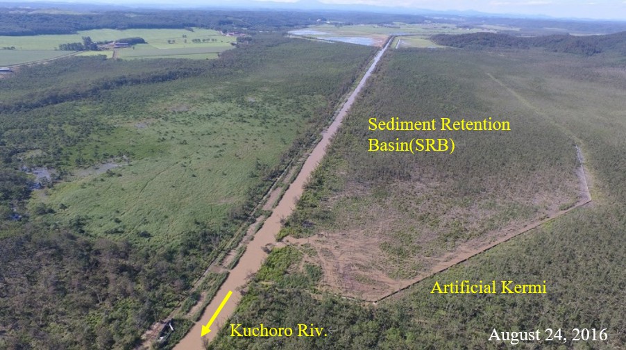
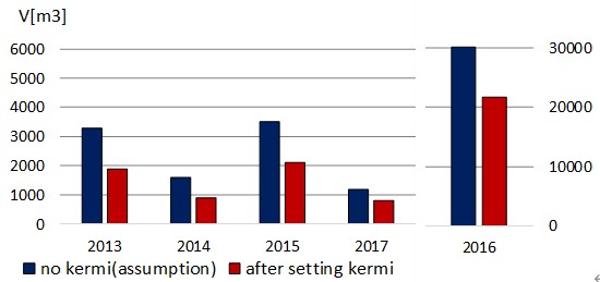
Sediment reduction measures have also been implemented at other sites. The sediment control area is one of the major approaches and has been implemented in the floodplain of the Kuchoro River, a tributary of the Kushiro River. 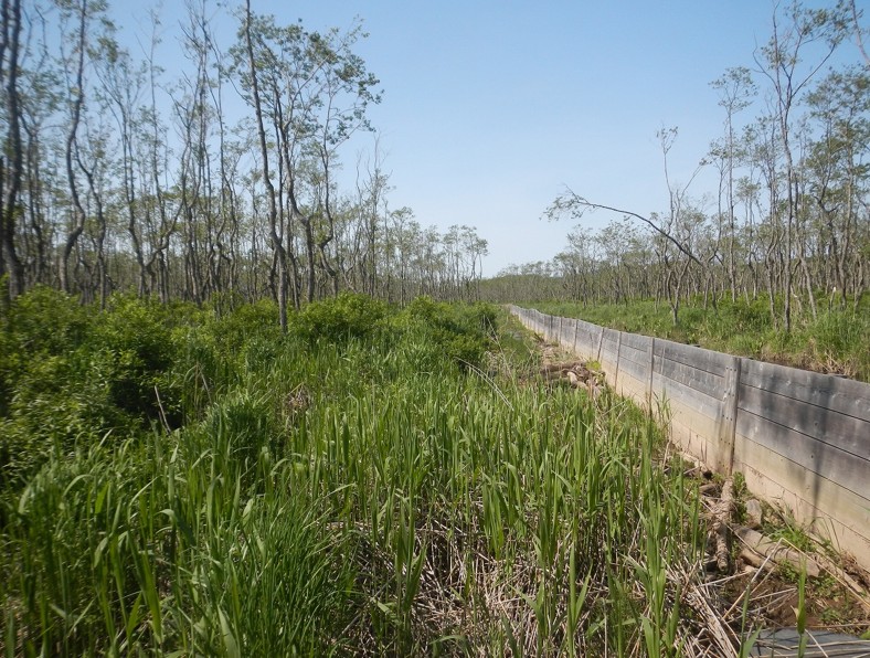 The sediment control area is enclosed by low walls and is designed to reduce sediment intrusion into the central wetland by impounding floodwater and promoting the deposition of suspended sediment. The low walls were constructed using wooden boards called “Artificial Kermi.” The original kermi refers to ridges of peat moss commonly found in bogs in Finland. The first area, located on the left side of the river, was completed in 2013. The total length of the kermi is 2.4 km, and the total area is 27.4 ha. An additional area on the right side of the river was constructed in 2020. Monitoring of the left-side area has been conducted to evaluate the effectiveness of the sedimentation design. During the major flood in 2016, the area was inundated for an extended period, and a large amount of sediment was deposited. 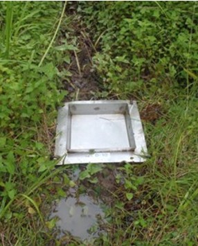 Sediment Trap: Square plates were set on the ground surface in the area. Sediments remained on the plate after inundation. (size: 0.22m ~0.22m) Sedimentation monitoring has been conducted since one year after the completion of the left-side area. Field observations were carried out for suspended sediment in the river channel and deposited sediment on the ground surface. Suspended sediment was measured at the upstream station, and discharge was measured simultaneously at the same location during flood events. The suspended sediment concentration was converted into sediment influx by multiplying it by the discharge. Within the area, sediment traps were installed at 21 locations, and the thickness of deposited sediment was measured after flooding. Based on these measurements, the total amount of sediment deposition in the area was estimated. The difference between the suspended sediment influx at the upstream station and the amount of sediment deposition within the area was defined as the sediment load flowing into the wetland. Monitoring is essential for quantifying how effectively the area reduces sediment inflow into the wetland. The results of the sedimentation monitoring, including total sediment transport, deposited sediment, and reduction rates, are summarized in the table below. The results indicate that approximately 10% of the suspended sediment was deposited within the area. This demonstrates the effectiveness of the area in reducing sediment inflow into the central wetland. Although the reduction rate was as low as 1% in 2017, this is considered to be due to the limited inundation from the channel, as the flood discharge was small and the water level did not rise significantly. 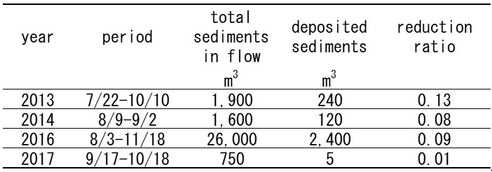 EvaluationA simulation model was developed to evaluate the sediment reduction effect by comparing cases with and without the sediment control area. Two-dimensional flow was calculated using the shallow water equations, and sediment transport was simulated using the advection–diffusion equation for suspended sediment. The simulation results for the 2016 flood are shown in the figures below. The upper figure shows the case without the area, while the lower figure shows the case with the area.In the case without the area, a large amount of sediment flows into the wetland, whereas in the case with the area, significant sediment deposition occurs within the area. In addition, the annual sediment reduction was estimated using this simulation model. The results indicate that the sediment reduction effect is approximately 30% due to the implementation of the area. 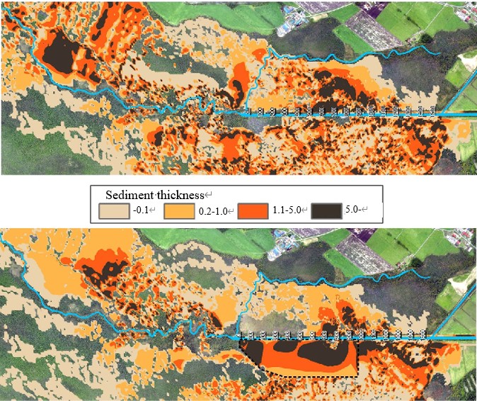
 Kushiro Wetland Restoration ProjectKushiro WetlandWetland Restoration Restoration Site 1 : Kayanuma, Old Channel Restoration 1 Restoration Site 2 : Numaoro, Old Channel Restoration 2 Restoration Site 3 : Kuchoro, Sediment Retention Basin Restoration Site 4 : Hororo, Reconversion of Farmland into Wetlands Kushiro Wetland Nature Restoration Council Project Goals Sediment reduction flowing into the wetland Implovement of habitat for fish Restoring Wetland Vegetation History 1 : Wetland Development History 2 : Shift Toward Wetland Conservation and Restoration Peatland |